If you look at a map of israel and jordan, it looks pretty straightforward. Two countries, one long river between them, a couple of seas, and some desert. Simple, right? Honestly, it isn’t. Not even close. When you actually get on the ground in the Levant, those neat lines on the paper start to feel a lot more fluid—and a lot more intense—than your average GPS would have you believe.
I remember standing at the Allenby Bridge crossing. It’s one of those places that feels like a glitch in the matrix. You’re technically leaving one jurisdiction and entering another, but the geography is so seamless it feels like one continuous landscape of dust and history. You’ve got the Jordan River—which, let's be real, is more of a stream in most places these days—acting as this massive geopolitical divider. It’s wild how a few meters of water can separate two entirely different worlds.
Navigating the Lines: What the Map of Israel and Jordan Actually Shows
Geographically, these two are neighbors in the tightest sense of the word. They share the Dead Sea, the Gulf of Aqaba, and the long, arid stretch of the Arava Valley. If you’re planning a trip, you’re basically looking at a vertical slice of the Middle East.
Jordan sits to the east, dominated by the high plateau of the East Bank. Israel is to the west, stretching from the Mediterranean down to the Red Sea. But the map is deceptive because it doesn't show the elevation drops. You go from Jerusalem, which is about 750 meters above sea level, down to the Dead Sea at roughly 430 meters below sea level in less than an hour. It’s a literal geological sinkhole.
The Border Realities
There are three main ways people actually traverse the map of israel and jordan. You have the Sheikh Hussein crossing in the north (near Beit She'an), the Allenby/King Hussein Bridge in the middle (near Jericho), and the Wadi Araba crossing in the south (between Eilat and Aqaba).
Each one has its own vibe. The south is usually the easiest for tourists. You walk across a sun-scorched tarmac, get your passport stamped, and suddenly you're in a land of pink sand and Bedouin tea instead of scuba diving and Eilat's duty-free malls. The Allenby Bridge is different. It’s the primary transit point for Palestinians and is managed with a level of security that feels like something out of a Cold War novel.
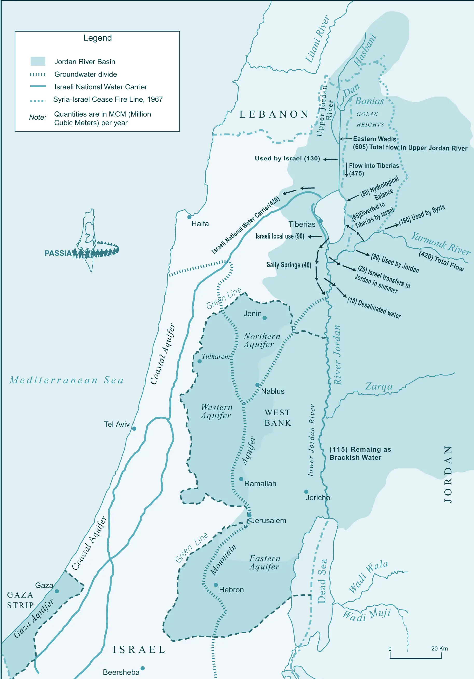
Water, Thirst, and the Shrinking Dead Sea
Look at the blue spots on the map. They’re lying to you.
The Dead Sea is disappearing. If you compare a map of israel and jordan from the 1960s to one from 2026, the change is horrifying. The sea has split into two distinct basins. The northern part is still deep and blue, but the southern part is basically a series of industrial evaporation ponds used by chemical companies on both sides to extract potash and bromide.
Why does this happen? Because both countries are thirsty. The Jordan River, which used to be a rushing torrent, has been diverted for agriculture and drinking water. By the time it reaches the Dead Sea, it’s mostly just a salty trickle. It’s a classic tragedy of the commons. Both nations know they need to save it, but when you’re living in one of the most water-stressed regions on Earth, "saving the sea" often takes a backseat to "keeping the taps running."
The Red Sea-Dead Sea Pipeline
For years, there was talk about a "Red-Dead" project. The idea was to pump water from the Red Sea, desalinate it for drinking, and then dump the leftover brine into the Dead Sea to keep the water levels up. It sounded great on paper. In reality? Political tensions, funding issues, and environmental concerns have kept the project in a state of "maybe later." Recently, Jordan has moved toward its own independent desalination projects in Aqaba because, frankly, they can't wait for a regional consensus that might never come.
The Jerusalem Factor
You can't talk about a map of israel and jordan without looking at the 1994 Peace Treaty. While the borders are mostly settled, Jordan still holds a "special role" over the Muslim holy shrines in Jerusalem. This is the "Waqf."
Even though Jerusalem is on the Israeli side of the 1967 Green Line, the Jordanian monarchy—the Hashemites—are the official custodians of the Al-Aqsa Mosque compound. It creates this bizarre, overlapping layer of authority. On the map, it's one color. In reality, it’s a delicate dance of diplomacy that keeps the whole region from boiling over.
Getting Around: The Practical Side of the Geography
If you’re trying to move between these two spots, don't trust Google Maps to give you the full story on "travel time."
- Rentals: You generally cannot take a rental car across the border. You drive to the terminal, leave the car (or drop it off), walk across, and pick up a new one on the other side.
- Visas: Jordan has a "Jordan Pass" which covers your visa fee and entry to places like Petra, but it only works if you stay for at least three nights.
- Timing: Friday afternoons and Saturdays are tricky. In Israel, it's Shabbat, so public transport dies. In Jordan, Friday is the main day of rest. If you're trying to cross on a Friday, start early or you'll be stuck in no-man's land.
The desert between the two—the Arava—is stunning. It’s mostly uninhabited, filled with jagged mountains that turn purple at sunset. It’s the kind of landscape that makes you feel tiny. Whether you're in the Israeli Negev or the Jordanian Wadi Rum, the geology is essentially the same, but the way the land is used is totally different. Israel has a lot of high-tech "desert agriculture" (think cherry tomatoes grown with brackish water), while the Jordanian side feels more rugged and traditional.
The "Green Line" vs. Reality
When people search for a map of israel and jordan, they’re often looking for the West Bank borders. This is where the "map" becomes a political statement. Depending on who printed the map, you’ll see the Green Line (the 1949 Armistice line), or you might see a map where the West Bank is integrated into Israel, or a map where it's labeled Palestine.
The physical reality is a patchwork. Area A, Area B, and Area C—these are the designations from the Oslo Accords. If you're driving through, you’ll see red signs warning Israeli citizens not to enter certain Palestinian-controlled areas. You’ll see checkpoints. You’ll see the separation barrier. A map makes these things look like clean lines, but they are physical, concrete, and deeply impactful on daily life.
Hidden Gems on the Border
Most people do the "Greatest Hits" tour: Jerusalem, Dead Sea, Petra. But if you look closely at the map, there are some weird, cool spots most people skip.
- Naharayim (The Island of Peace): Located at the confluence of the Jordan and Yarmouk rivers. It was an old hydroelectric power station. For a while, there was a special arrangement where Israelis could farm Jordanian land, but that lease ended recently. It’s a haunting, beautiful spot that shows how much "cooperation" has fluctuated over the years.
- Mount Nebo: In Jordan, this is where the map becomes religious. Tradition says this is where Moses looked out over the "Promised Land." On a clear day, you can see the Jericho oasis and the lights of Jerusalem. It’s one of the few places where you can see the entire map of israel and jordan laid out in 3D right in front of you.
- The Baptism Site (Al-Maghtas/Qasr el Yahud): Both sides claim to have the "official" spot where Jesus was baptized. They are literally twenty feet apart, separated by a muddy, narrow Jordan River. You can wave to people on the other side. It’s surreal.
Why the Topography Matters
The Rift Valley—the massive crack in the earth's crust that runs from Turkey down to East Africa—is what created this geography. It’s why the region is so prone to earthquakes. It's also why the soil is so varied.
Jordan is mostly a high-altitude desert. Israel is a mix of Mediterranean coastal plains, rolling hills, and the southern desert. This contrast is why the weather can be so localized. It might be snowing in Amman and Jerusalem (which happens more than you'd think!) while people are sunbathing in Aqaba and Eilat just a few hundred kilometers south.
Actionable Steps for Exploring the Map
If you’re actually planning to navigate this area, here is how you do it without losing your mind.
Check the Border Status Daily
Political situations change. Before heading to any crossing, check the official government websites for both the Israeli Population and Immigration Authority and the Jordanian Ministry of Interior. Some borders close for holidays you’ve never heard of.
Don't Rely on a Single Map
Use digital maps for navigation, but buy a physical topographic map if you plan on hiking in places like the Dana Biosphere Reserve or the Negev. GPS signal can be spotty in the deep canyons (Wadis), and a physical map won't run out of battery.
Handle the Visa Before You Arrive
Unless you are from a visa-exempt country, getting your Jordanian visa in advance or through the Jordan Pass is much smarter than hoping for a visa-on-arrival at a land border, which isn't always an option at the King Hussein (Allenby) Bridge.
Understand the Currency Gap
You’ll be switching between Israeli New Shekels (ILS) and Jordanian Dinars (JOD). The Dinar is pegged to the US Dollar and is actually quite "strong," so don't be surprised when your money doesn't go as far as you expected in Amman. Most border crossings have exchange booths, but the rates are usually predatory. Get enough to get to the nearest city and use an ATM there.
Respect the Buffer Zones
When you are near the border, especially in the north or near the Dead Sea, stay on marked paths. There are still old minefields in some of the border zones. They are fenced off and clearly marked with yellow signs, but don't go wandering into "empty" fields for a photo op.
The map of israel and jordan is a living document. It’s a record of ancient history, 20th-century wars, and 21st-century environmental challenges. Seeing it on a screen is one thing; feeling the change in the air as you cross the Rift Valley is another thing entirely. Stick to the crossings, respect the local laws, and keep your eyes open—the most interesting things are usually the ones the map-makers didn't bother to label.