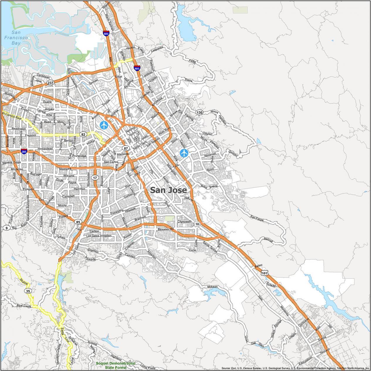
If you’ve ever tried to navigate the San Jose California map USA without a GPS, you probably ended up in a suburban cul-de-sac wondering where the skyscrapers went. Honestly, it’s a weird city. It is the tenth-largest city in the United States, yet it feels like a collection of twenty different small towns that were forced to hold hands.
The geography here isn't just a grid; it’s a chaotic sprawl of "Dutch" Hamann’s 1950s dreams and high-speed expressways. Most people expect a traditional urban core. Instead, they get a 180-square-mile puzzle piece nestled between the Santa Cruz Mountains and the Diablo Range.
The Weird Geography of the South Bay
San Jose sits at the very bottom of the San Francisco Bay. If you look at a San Jose California map USA from a bird's-eye view, you’ll see it doesn't actually touch much water. Only the historic neighborhood of Alviso really connects the city to the Bay. The rest is a broad floodplain that slopes upward into the foothills.
Local residents usually orient themselves by the mountains. To the east, you have the golden, dry ridges of the Diablo Range, topped by the white domes of the Lick Observatory on Mount Hamilton. To the west are the dark green, redwood-heavy Santa Cruz Mountains.
If you see both sets of mountains at once, you’re likely facing south toward Morgan Hill. If you see no mountains at all, you’re probably looking north toward the Bay and the salt ponds.
Why the Roads Make No Sense
The street layout is notoriously frustrating. Why? Because of the "Expressways." San Jose has a unique system of high-speed county roads like Lawrence, San Tomas, and Almaden Expressway. They look like freeways but have traffic lights. It's a bizarre hybrid that makes "going across town" a test of patience.
- Highway 101: This is the spine of the city, running northwest to southeast.
- Interstate 280/680: Locally known as the Sinclair Freeway, it loops through the heart of the city.
- Highway 87: The Guadalupe Freeway. It’s the shortcut to the airport, but it’s almost always jammed.
- The 85 Loop: This bypasses the city center entirely, cutting through the affluent southwestern suburbs.
One of the most disorienting things for newcomers is how Highway 85 is labeled. It technically runs east-west across the south side, but the signs say North and South because it’s a bypass for 101. It’s a mess.
Navigating the 18 Major Neighborhoods
You can't talk about a San Jose California map USA without mentioning the "annexation madness." Back in the mid-20th century, City Manager A.P. "Dutch" Hamann annexed land nearly 1,400 times. This created a city that looks like a Swiss cheese map, with "pockets" of unincorporated county land sitting right in the middle of city neighborhoods.
The Historic Core
Downtown is the cultural hub, but it’s small. You’ve got the SAP Center (where the Sharks play) and the Tech Interactive. Just outside the high-rises, you hit Japantown, one of only three remaining in the entire country. It’s incredibly walkable and full of authentic tofu shops and boutiques.
The Affluent South and West
Willow Glen is basically the "Main Street USA" of San Jose. It has that cozy, small-town vibe with expensive bungalows and boutique shops on Lincoln Avenue. Further south, you hit Almaden Valley. This area is tucked into the hills and was once home to the richest mercury mines in the world at Almaden Quicksilver Park.
The Cultural East Side
Alum Rock and Mayfair are the heart of the city’s Mexican-American heritage. Alum Rock Park, established in 1872, is actually California's oldest municipal park. It’s rugged, beautiful, and feels miles away from the tech campuses of North San Jose.
Transit Hubs and the Silicon Valley Loop
Most people arrive via San Jose Mineta International Airport (SJC). It’s weirdly close to downtown—less than four miles away. This is why San Jose doesn't have super-tall skyscrapers; the FAA limits building heights because planes fly directly over the city center.
The Diridon Station is the primary transit nerve center. You can catch the Caltrain up to San Francisco, the ACE train to the Central Valley, or the VTA Light Rail to get around locally.
The Light Rail is split into three main lines:
- Blue Line: Connects the tech north (Baypointe) to the suburban south (Santa Teresa).
- Green Line: Runs from North San Jose down to the Winchester Mystery House area.
- Orange Line: An east-west line that links Mountain View to Alum Rock.
What Most People Get Wrong About San Jose
The biggest misconception is that San Jose is a "suburb" of San Francisco. It isn't. It’s bigger, more populous, and serves as the economic engine for the entire region. When people search for a San Jose California map USA, they are often surprised to see how much land the city actually covers. It’s 180 square miles of industry, residential sprawl, and hidden trails.
Another surprise? The "Mystery House." The Winchester Mystery House is located right across from Santana Row. On a map, this looks like a tiny spot, but the estate is a sprawling architectural nightmare built by Sarah Winchester to confuse ghosts. It perfectly mirrors the confusing layout of the city itself.
Actionable Tips for Navigating San Jose
If you are planning a visit or moving here, stop relying on the general "Bay Area" maps. They don't show the nuance of the South Bay.
- Download the VTA App: If you plan on using public transit, the Light Rail is decent, but the bus system is complex. The app is essential.
- Use Mountains for North/South: East is the dry hills (Mt. Hamilton). West is the green hills (Santa Cruz).
- Avoid the 101/880 Interchange at 5 PM: Just don't do it. It’s one of the worst bottlenecks in Northern California.
- Explore the "Nodes": Don't just stay downtown. Go to the Rose Garden for the flowers, Santana Row for the luxury shopping, and Alviso for the sunset over the salt ponds.
The San Jose California map USA is a testament to rapid, post-war growth. It’s a city that grew too fast to have a perfect grid, but that’s exactly what makes its various "urban villages" so distinct. Whether you're hiking the hills of Alum Rock or grabbing a coffee in Willow Glen, you're experiencing a city that refuses to be just one thing.
To get the most out of your trip, start by pinning the major landmarks—Diridon Station, Santana Row, and San Jose State University—and then fill in the gaps between the expressways. You’ll find that the "Capital of Silicon Valley" is a lot more than just office parks and data centers.