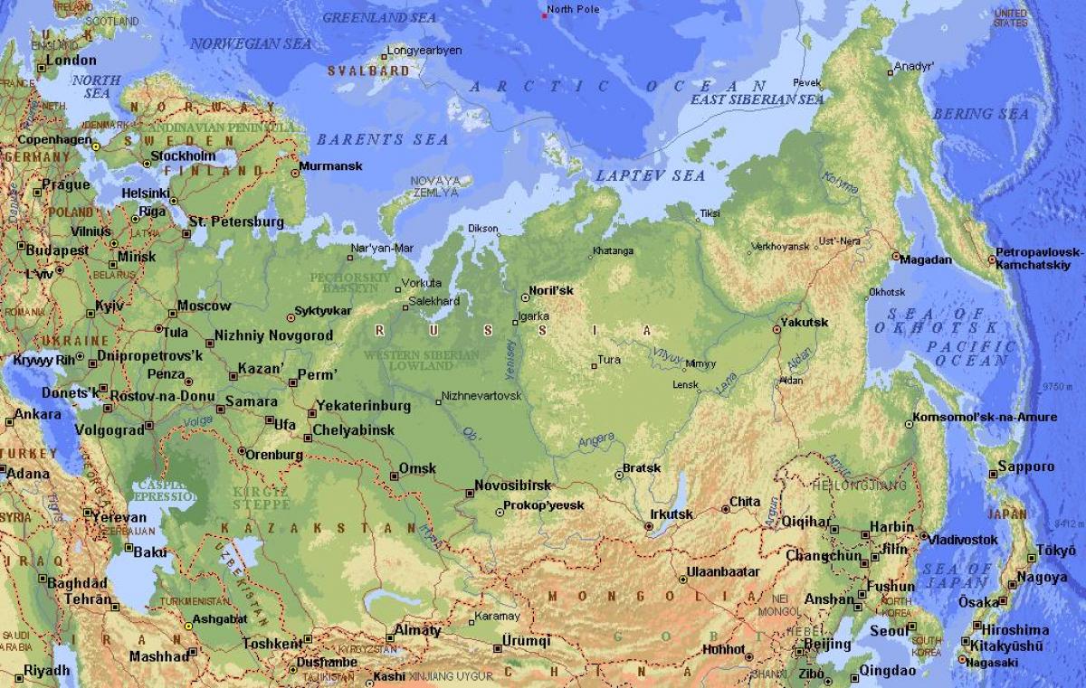
Russia is massive. Honestly, looking at a physical map of Russia for the first time is usually a bit of a shock because the scale just doesn't compute. You're looking at eleven time zones. Most people think of it as just a giant block of frozen tundra, but that's a total oversimplification that ignores the actual geology. It’s a land of extremes. From the sub-zero plains of Siberia to the surprisingly lush, almost Mediterranean feel of the Black Sea coast, the topography dictates everything about how people live there.
The map is basically a story of two halves divided by a single mountain range. To the west, you've got the European Plain. It's flat. Mostly. This is where the vast majority of the population lives because, frankly, the geography is more forgiving. But once you cross the Ural Mountains, everything changes. The terrain becomes a grueling mix of swamps, dense forests, and high-altitude plateaus that have historically broken the wills of explorers and invaders alike.
The Urals: Not Just a Line on a Map
Everyone knows the Ural Mountains represent the border between Europe and Asia. But if you actually look at a physical map of Russia, the Urals aren't these jagged, soaring peaks like the Himalayas or the Rockies. They’re old. They’re weathered. Most of the range is actually quite low, with the highest point, Mount Narodnaya, only reaching about 1,895 meters.
Think of them as a speed bump rather than a wall. They are incredibly rich in minerals—iron, coal, even gemstones—which is why cities like Yekaterinburg exist where they do. Without these mountains, the industrial backbone of the country would look completely different. They aren't just a geographic marker; they are a resource goldmine that fundamentally shifted the country's economy during the Soviet era.
The transition from the West Russian Plain into the West Siberian Plain is one of the most dramatic shifts in landscape you’ll see. On the map, it looks like a flat green expanse. In reality? It’s one of the largest wetlands on the planet. When the snow melts in the spring, the Ob River and its tributaries overflow, turning thousands of square miles into an impassable marsh. If you were trying to build a road here, you’d realize pretty quickly why much of Russia relies so heavily on the Trans-Siberian Railway. You can't just pave over a swamp that spans a continent.
The Siberian Trap and the Great Shield
Moving further east, the physical map of Russia starts to look a lot more rugged. This is the Central Siberian Plateau. It’s a massive block of ancient volcanic rock known as the Siberian Traps. About 250 million years ago, this area saw one of the largest volcanic events in Earth's history. It literally paved the region in basalt.
Because of this geological history, the ground is incredibly hard. Combine that with permafrost—ground that stays frozen year-round—and you have a nightmare for modern engineering. This is why you see houses in Yakutsk built on stilts. If they were built directly on the ground, the heat from the building would melt the ice, and the whole structure would sink into the mud.
- The Lena River: One of the longest in the world, flowing north into the Arctic Ocean.
- Lake Baikal: Located in a rift valley, this is the deepest lake on Earth and holds about 20% of the world's unfrozen freshwater.
- The Stanovoy Range: Rugged mountains that separate the Siberian drainage from the Pacific.
Lake Baikal is a freak of nature. It’s so deep (over 1,600 meters) that it contains more water than all the Great Lakes in North America combined. On a map, it looks like a blue crescent sliver, but the geological forces pulling the earth apart there are still active. It’s basically a nascent ocean.
The Southern Fringe and the Ring of Fire
The southern borders of Russia are where the "flat" narrative goes to die. The Caucasus Mountains, stretching between the Black and Caspian Seas, are where you find Russia’s highest point: Mount Elbrus. At 5,642 meters, it makes the Urals look like hills. This is a region of jagged peaks and deep valleys, creating a natural barrier that has historically isolated different ethnic groups and cultures.
Then there’s the Kamchatka Peninsula on the far eastern edge. This is part of the Pacific Ring of Fire. If you look at a high-resolution physical map of Russia, Kamchatka is dotted with over 160 volcanoes, 29 of which are still active. Klyuchevskaya Sopka is the star of the show here. It’s a perfectly conical volcano that’s almost constantly venting steam or ash. It’s a landscape that feels more like Iceland or New Zealand than the popular image of Russia.
The variety is actually staggering. You go from the Caspian Depression—which is actually below sea level—to the high-altitude alpine meadows of the Altai Mountains near the Mongolian border. The Altai region is stunning. It’s often called the "Green Pharmacy" because of the sheer number of medicinal plants that grow there, fueled by glacial meltwater.
Why the Rivers Flow North (And Why It’s a Problem)
One of the most defining features of a physical map of Russia is the river system. Most of the great Siberian rivers—the Ob, the Yenisei, and the Lena—flow from south to north.
This creates a massive logistical headache. In the spring, the southern parts of the rivers thaw out while the northern mouths are still choked with Arctic ice. The water has nowhere to go. Result? Massive, catastrophic flooding every single year. It also means these rivers are less useful for international trade than, say, the Mississippi or the Rhine. They lead to a frozen ocean for half the year.
The Volga is the exception. It’s the longest river in Europe and flows into the Caspian Sea. It’s the artery of the Russian heartland. But even the Volga is heavily managed today, with a series of massive dams and reservoirs that have completely altered the natural physical map of the region.
Practical Insights for Navigating the Landscape
Understanding the physical geography of Russia is about more than just memorizing mountain ranges; it's about understanding the limits of human movement.
If you’re planning to travel or study the region, keep these geographic realities in mind:
- The Permafrost Line: Roughly two-thirds of Russia is covered by permafrost. This affects everything from where cities are built to how pipelines are laid. It's an invisible geographic wall.
- The "Black Earth" Belt: Southwest Russia contains some of the most fertile soil on the planet (chernozem). This is the breadbasket of the country and the reason why this specific part of the physical map is so densely populated with farms.
- The Taiga vs. The Tundra: The Taiga is the massive coniferous forest that covers most of the country. North of that is the Tundra, where trees can't grow because the growing season is too short and the ground is too frozen.
- Maritime Access: Despite having the world's longest coastline, Russia has surprisingly few warm-water ports. This single geographic fact has driven Russian foreign policy for centuries.
To truly grasp the physical map of Russia, you have to stop looking at it as a static image. It's a dynamic, harsh, and incredibly diverse environment. You can't just drive across it like you’re on a road trip across the US. The geography won't let you. Whether it's the impassable marshes of Western Siberia or the volcanic peaks of the Far East, the land itself dictates the pace of life.
If you're looking to explore further, start by looking at topographic layers on digital maps. Focus on the elevation changes around the Yenisei River—it marks the literal "step up" from the lowlands to the plateaus. Or check out satellite imagery of the Volga Delta to see how a river can turn a desert-fringe area into a labyrinth of greenery. The map is a lot more alive than the old school textbooks lead you to believe.