The F train is basically the spine of the New York City subway system, stretching from the woodsy vibes of Jamaica, Queens, all the way down to the salty air of Coney Island. It’s long. It’s complicated. If you’re staring at an nyc f train map for the first time, it probably looks like a chaotic orange vine tangling its way through three different boroughs. But here’s the thing: that map you see on the wall of the station? It’s often a lie. Not because the MTA is trying to trick you, but because the F train is the king of "planned service changes."
Navigating this line requires a bit of street smarts and a lot of patience. One minute you’re cruising along the Culvert Viaduct in Brooklyn with a killer view of the Statue of Liberty, and the next, you’re hearing a garbled announcement that your train is suddenly running on the E line. It happens. You’ve got to be ready for it.
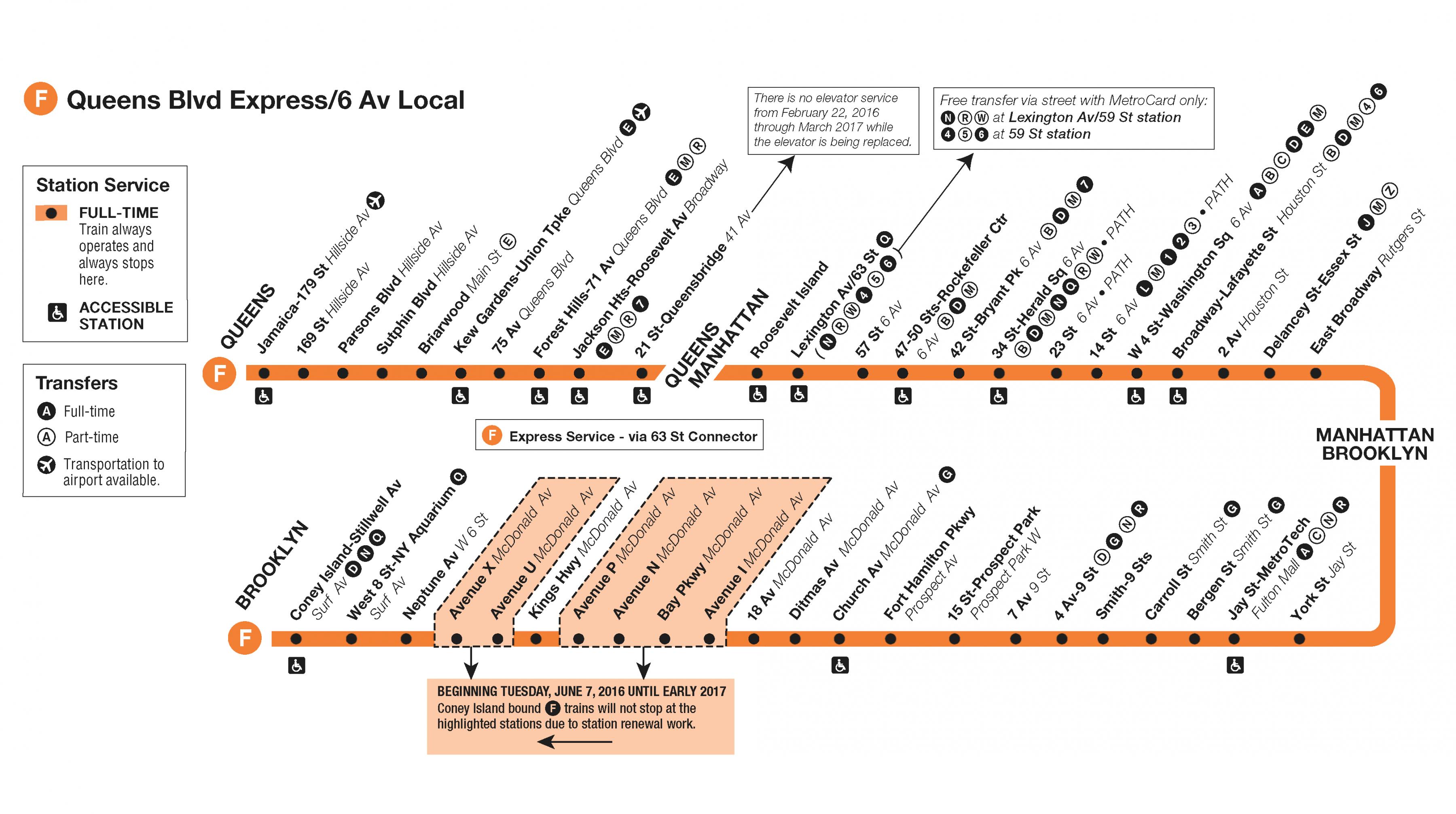
Where the NYC F Train Map Actually Goes
To understand the F, you have to look at its trajectory. It starts at Jamaica–179th Street in Queens. This is a massive terminal. From there, it heads west, hitting major hubs like Forest Hills–71st Avenue. This is where things get interesting for commuters. In Queens, the F usually runs express during rush hours, skipping a bunch of local stops to get people into Manhattan faster. But "usually" is the keyword there. Always check the digital signs.
Once it hits Manhattan, the F turns into the Sixth Avenue Local. It hits the big ones: Rockefeller Center, Bryant Park, and West 4th Street. If you’re trying to get to the West Village or the shopping districts in Midtown, the F is your best friend. But then it dives under the East River through the Rutgers Street Tunnel. This tunnel is a frequent victim of maintenance closures, especially on weekends. When that happens, the nyc f train map essentially breaks, and you’ll find yourself taking a shuttle bus or a weirdly rerouted A train.
Brooklyn is where the F shows its true length. It runs through DUMBO, into Downtown Brooklyn, and then starts the long, slow crawl down through Park Slope, Kensington, and Midwood. By the time you reach Avenue X, you’ve basically traveled across a small country. The final stop is Coney Island–Stillwell Avenue, a beautiful, sprawling station where you can smell the Nathan’s Hot Dogs from the platform.
The Infamous F Express and the Culver Line
There’s a lot of drama surrounding the "F Express" in Brooklyn. For years, residents in South Brooklyn begged for express service to cut down their hour-long commutes. The MTA finally introduced a limited F Express service in 2019. It skips a handful of stops between Jay Street-Metrotech and Fourth Avenue-9th Street. It sounds great, right? Honestly, it’s a bit of a mixed bag. Because the tracks are so old and the signaling is, well, vintage, the "express" sometimes ends up sitting behind a local train anyway.
If you’re looking at a standard nyc f train map, you might see those little white diamonds or circles indicating express stops. Just remember that this service is usually restricted to very specific peak hours. If it’s 11:00 PM on a Tuesday, don't count on skipping those local stops. You’re in for the long haul.
Why the Map Isn't Always What It Seems
New York is old. The subway is older. Because of this, the F train is perpetually under construction. You might see a map that shows the F stopping at 21st St-Queensbridge, but then you get to the platform and realize the train is being diverted over the 53rd Street tunnel instead. This is usually due to the MTA’s "FASTRACK" program or general signal modernization.
- Signal Modernization (CBTC): The MTA has been working on installing Communications-Based Train Control on the Queens Boulevard line. This is a high-tech system that allows trains to run closer together. It’s great for the future, but right now, it means the F train map is frequently disrupted on weekends.
- The Rutgers Tunnel Rehab: Ever since Hurricane Sandy, the tunnels under the river have needed massive work. The Rutgers Street Tunnel, which carries the F between Manhattan and Brooklyn, has seen its fair share of closures.
- The 63rd Street Connection: This is a big one. The F uses the 63rd Street tunnel to get from Queens to Manhattan. However, maintenance here often forces the F to run on the E line tracks to 53rd Street. If you aren't paying attention, you might end up at Lex/53rd instead of Lex/63rd. They aren't that far apart, but if you're late for a meeting, those ten blocks feel like ten miles.
Tips for Deciphering the Map in Real Time
Don't just look at the paper map. Seriously. It’s a historical document at this point. Instead, you need to use the live tools. The MTA has a "Live Subway Map" on their website that actually shows the trains moving in real-time. It’s a game-changer. If there’s a reroute, the digital lines actually shift to show where the train is going.
Also, keep an eye on the "M" train. In many parts of Manhattan and Queens, the F and the M share tracks. They are like siblings that sometimes get along and sometimes go their separate ways. If you see an M train, you can usually take it to the same Manhattan stops as the F, but the M won't take you to Brooklyn—it heads off toward Bushwick instead.
Surprising Facts About the F Train
The F train is one of the few lines that offers a "view." Most of the NYC subway is underground and, frankly, kind of grimy. But the F train pops out of the ground at Smith-Ninth Streets in Brooklyn. This station is actually the highest subway station in the world, sitting nearly 90 feet above the Gowanus Canal. The view of the Manhattan skyline from here is genuinely breathtaking. It’s one of those "only in New York" moments that makes the 45-minute commute worth it.
Another weird detail? The F train is the only line that serves the Roosevelt Island station. If you want to see the ruins of the smallpox hospital or just get a quiet view of the city, the F is your only underground way there. Of course, you could take the tram, but the F train is the workhorse that keeps the island connected to the rest of civilization.
Dealing with the "Showtime" and Local Culture
Because the F train is so long and crosses so many neighborhoods, the "vibe" changes depending on where you are. In Queens, it’s very much a commuter atmosphere—lots of people reading or staring at their phones. In Manhattan, it gets crowded with tourists and shoppers. By the time you hit Brooklyn, it’s a mix of hipsters, families, and beach-goers.
You will almost certainly encounter street performers. "Showtime" is a staple of the F train. Whether you love it or hate it, it’s part of the experience. Just keep your bags close and enjoy the acrobatics, or do what the locals do: stare intently at a random ad for a dental school until they move to the next car.
Actionable Steps for Navigating the F Train
If you want to master the nyc f train map, stop thinking of it as a static image. Treat it like a weather forecast. It changes based on the day, the hour, and the whims of the MTA.
- Download the MYmta App: It’s the official source. It’s not perfect, but it’s better than guessing. It will tell you if the F is running local or express or if it's being diverted to the E line.
- Check the "Planned Work" Posters: Every station has them. They are usually yellow or green. Take ten seconds to read them before you swipe your OMNY or MetroCard. It could save you an hour of sitting on a shuttle bus.
- Listen to the Conductor: I know, the speakers are usually terrible. But if the train is sitting at a station for more than two minutes with the doors open, something is up. Pull your headphones out and listen.
- Know the Alternatives: If the F is messed up in Brooklyn, can you walk to the G? If it’s stuck in Queens, is the E or the R nearby? Always have a Plan B.
- Look Up: When you’re on the elevated sections in Brooklyn, actually look out the window. It’s one of the best ways to see the "real" New York away from the tourist traps of Times Square.
The F train is a microcosm of New York City itself: it's loud, it's unpredictable, it's a little bit rough around the edges, but it gets the job done. Once you learn to read the "real" map—the one that exists in the live updates and the conductor's announcements—you'll be navigating the city like a pro. Just remember that the trip to Coney Island is always longer than you think it is, so bring a book.