Disney World is massive. Seriously, it's about the size of San Francisco or twice the size of Manhattan, which means looking at a map of Disneyworld resorts for the first time is honestly a bit overwhelming. You aren't just looking at a few hotels clustered around a theme park. You're looking at over 25 unique Disney-owned properties spread across 43 square miles of Florida swampland and pine scrub.
Most people make the mistake of thinking they can just "walk around" and see everything. You can't. If you pick a resort on the wrong side of the property, you might spend two hours a day just sitting on a bus. That's time you could’ve spent eating a Dole Whip or finally riding Rise of the Resistance.
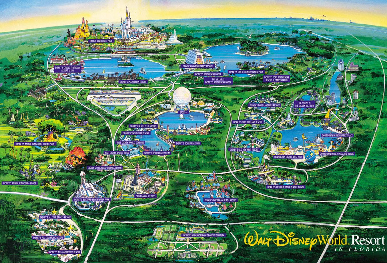
Where Everything Actually Sits on the Map
To understand the layout, you have to stop thinking about Disney World as one big circle. It’s more like a series of interconnected hubs.
At the very top of the map, you’ve got the Magic Kingdom area. This is the "classic" Disney vibe. If you’re looking at a map of Disneyworld resorts in this specific pocket, you’ll see the Monorail loop. It connects the Contemporary, the Polynesian, and the Grand Floridian directly to the park. These are the heavy hitters. They’re expensive, sure, but the convenience is hard to beat. Wilderness Lodge is also up here, tucked away in the woods, though it doesn't have a Monorail stop—you take a boat instead.
Further south, things get a bit more spread out. You hit the Epcot and Hollywood Studios area. This is arguably the best place to stay right now because of the Disney Skyliner. The Boardwalk, Yacht Club, and Beach Club are all within walking distance of Epcot’s International Gateway. If you look at the map, you’ll see these resorts basically wrap around Crescent Lake.
Then you have the Animal Kingdom area way out west. It feels isolated because it is. When you look at the geographic spread, Animal Kingdom Lodge is kind of on its own little island of savanna. It’s gorgeous, but you are relying heavily on buses or rideshares to get anywhere else.
The Transportation "Spaghetti" Factor
Understanding the map of Disneyworld resorts requires understanding the lines connecting the dots. It isn’t just about where the hotel is; it’s about how the hotel moves you.
- The Monorail: It only serves the Magic Kingdom area and Epcot (via a transfer at the Transportation and Ticket Center).
- The Skyliner: This gondola system connects Pop Century, Art of Animation, Caribbean Beach, and Riviera Resort to Epcot and Hollywood Studios.
- Boats: These run in the Magic Kingdom loop, the Epcot/Studios loop (Friendship boats), and from the Disney Springs resorts.
- Buses: Every resort has them. They go everywhere. But they are the "slowest" variable on the map.
If you’re staying at a "Value" resort like All-Star Movies, look at the map. You are at the bottom left. You are far from everything except Animal Kingdom. You’ll be on a bus for 20 minutes just to get to the Magic Kingdom gate. Some people don't mind. Others find it a dealbreaker once they realize how much of their vacation is spent staring at the back of a bus seat.
Why Proximity Isn't Always What It Seems
Let's talk about the "Disney Springs" area. On a standard map of Disneyworld resorts, these hotels—Saratoga Springs and Old Key West—look like they are right in the thick of the action. And they are, if your "action" is shopping and dining. But if your goal is hitting the parks at rope drop, these resorts are sprawling.
Saratoga Springs is so big it has multiple bus stops within the resort itself. You could spend ten minutes just driving around the hotel before you even leave the property. Honestly, it’s a lot.
Then there’s the "Bungalow" and "Cabin" factor. Look at Fort Wilderness. It looks like a nice green patch on the map near the Magic Kingdom. It is massive. You actually need a golf cart to get around the resort efficiently. People forget that "close on the map" doesn't always mean "short walk to the lobby."
The Hidden Complexity of the Epcot Resorts
If you zoom in on the Epcot section of the map of Disneyworld resorts, you'll notice something interesting. The Swan and Dolphin hotels sit right there next to the Disney-owned Boardwalk. But they aren't actually owned by Disney—they're Marriott properties.
This matters for your map planning because while they share the same prime location and boat transportation, they don't always get the same perks (though they currently get Extended Evening Hours, which is a huge win). Staying here gives you the best "map position" for a lower price point than the Yacht Club, usually. You're basically a ten-minute walk from the back entrance of Epcot. It’s the ultimate "pro move" for foodies who want to hit the Food & Wine Festival without needing a taxi home.
Choosing Your Hub Based on Your Priorities
So, how do you actually use this information? You match your resort choice to your "priority park."
If you have toddlers, you’re likely spending 70% of your time at Magic Kingdom. Staying at the Contemporary or Bay Lake Tower means you can walk—yes, walk—to the park. When the fireworks end and 40,000 people are rushing for the Monorail, you just stroll back to your room. It’s a game-changer.
If you’re a Star Wars fan or a Marvel geek (over at Epcot's Guardians coaster), the Skyliner resorts are your best friend. Look at the map for Caribbean Beach. It acts as the central hub for the Skyliner. From there, you can zip to two different parks in minutes. It makes taking a mid-day nap or a pool break actually feasible.
Practical Realities of the "Value" Resorts
The All-Star Resorts (Music, Movies, Sports) and Pop Century are often grouped together in people's minds. But look at their physical locations. The All-Stars are tucked away in the southwest corner. Pop Century and Art of Animation are more central.
Pop Century has the Skyliner. The All-Stars do not.
Even though they are all "Value" hotels, the map of Disneyworld resorts shows that Pop Century has a massive logistical advantage. You'll pay a "Skyliner tax" (a slightly higher nightly rate), but most veterans will tell you it’s worth every penny to avoid the All-Star bus lines.
Mapping the Logistics of Dining and Logistics
You also have to consider where you’re going to eat. If you stay at Animal Kingdom Lodge, you have some of the best food on property (Jiko and Sanaa), but you are tethered to that resort. If you want to eat at Chef Mickey’s, you have to travel from the far west of the map to the far north.
That’s a two-step journey: Bus to a park, then Monorail to the hotel. Or a $20 Lyft.
Most people don't account for the "cross-resort" travel time. Disney’s internal bus system doesn't go from hotel to hotel. It only goes Hotel-to-Park or Hotel-to-Disney Springs. If you see a restaurant you love at a different resort, check the map. If it’s not on the same transportation line (like the Monorail or Skyliner), leave yourself at least 60 to 90 minutes to get there. It sounds crazy, but that’s the scale we’re dealing with.
Nuance: The Construction Factor
The map of Disneyworld resorts is never truly static. Right now, for instance, the Polynesian has been undergoing massive changes with the new DVC tower (Island Tower). This affects walkways and noise levels.
Similarly, the Boardwalk has been seeing a slow rollout of room refurbishments and new dining like The Cake Bake Shop. When you look at a map, it doesn't tell you that a certain walkway might be blocked or that a construction fence is obscuring your "lake view." Always cross-reference the current map with recent guest photos from sites like WDWMAGIC or the DISBoards to see what’s actually happening on the ground.
Actionable Steps for Your Mapping Strategy
Don't just look at a PDF of the map and pick the prettiest hotel. Follow these steps to ensure you don't end up stranded in a logistical nightmare.
Identify your "Anchor Park" first. Decide which park you will visit most. If it's Magic Kingdom, stay in the Magic Kingdom Resort Area. If it's Epcot or Hollywood Studios, stay in the Epcot Resort Area or on the Skyliner line.
Check the "Internal" map of the resort. Once you pick a hotel, look at its specific layout. Some resorts, like Caribbean Beach or Saratoga Springs, are so large that you might want to request a room in a specific "Preferred" building near the lobby or transportation hub. Being in the furthest building at Port Orleans Riverside can add a 15-minute walk just to get your morning coffee.
Use a rideshare app to "test" distances. Open Uber or Lyft while you’re planning. Type in the name of the resort you’re considering and the park you want to visit. Look at the drive time. If it says 18 minutes by car, it will likely be 35-45 minutes by Disney bus once you factor in waiting and loading. This gives you a "real world" perspective that the flat map won't show you.
Factor in the Disney Springs "Secret" Entrance. If you stay at Saratoga Springs, there is a walking path to Disney Springs. If you stay at Port Orleans (French Quarter or Riverside), there is a ferry boat. This makes these resorts great for people who want easy access to nightlife and dining without needing to navigate the main theme park transportation hubs.
The map of Disneyworld resorts is a tool, not just a picture. If you use it to plan your movement rather than just your sleep, you’ll save hours of frustration. Disney is a lot of work, but getting the geography right is the first step to actually enjoying it. Keep your eyes on the transportation lines, not just the icons, and you’ll be ahead of 90% of the other guests.
Final Tactical Tip: Download the My Disney Experience app before you book. Use the "Get Directions" feature between a potential resort and a park. It will show you exactly which transportation options are available and roughly how long it takes. It’s the most accurate "live" map you can get.