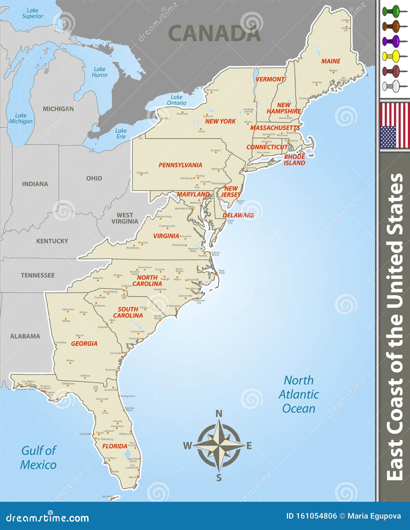
The Atlantic coastline isn't just a strip of sand. It's a massive, 2,000-mile stretch of concrete, history, and surprisingly dense geography. When most people look at an east coast usa map with cities, they see the big hitters. NYC. DC. Maybe Miami if they’re looking far enough south. But honestly, if you’re trying to navigate the "Eastern Seaboard," the map is a total lie if you don't understand the corridors.
It’s crowded.
The East Coast is home to about 118 million people. That is more than a third of the entire U.S. population squeezed into a relatively narrow band of land. If you're planning a road trip or just trying to wrap your head around the logistics of the Atlantic states, you've got to look past the dots on the page.
The Reality of the Megalopolis
Have you ever heard of BosWash? It sounds like a laundry detergent, but it’s actually the term urban planners use for the continuous sprawl from Boston to Washington, D.C. If you look at an east coast usa map with cities in this region, the lines between where one city ends and another begins are basically non-existent.
You’ve got the heavyweights.
Boston sits at the top, a maze of one-way streets and colonial brick. Then you drop down through Providence and into the sheer density of the New York metropolitan area. This isn't just Manhattan. It’s Jersey City, Newark, Yonkers, and Stamford. South of that, Philadelphia anchors the Delaware Valley, leading into Baltimore’s Inner Harbor and finally the political machine of D.C.
It’s one giant, interconnected machine.
Transportation here is dominated by the I-95 corridor and Amtrak’s Northeast Regional lines. In fact, according to the Bureau of Transportation Statistics, the Northeast Corridor is the only place in the U.S. where rail travel actually competes with flying for efficiency. If you're looking at a map and think you can "breeze through" from Philly to New York in an hour, you're forgetting about the "New Jersey Turnpike factor." Traffic here is a physical entity. It has a pulse.
Breaking Down the East Coast USA Map with Cities by Region
The coast isn't a monolith. It’s actually three very distinct vibes.
The North Atlantic: New England Grit
Up here, the cities are smaller but older. Portland, Maine, isn't just for lobster rolls; it’s a deep-water port with a rugged, industrial history. Manchester and Portsmouth in New Hampshire provide the gateway to the mountains, while Boston remains the undisputed "hub."
What’s interesting is how these cities are positioned. They were built for boats, not cars. When you look at a map of Massachusetts or Rhode Island, the cities are huddled together along the estuaries.
The Mid-Atlantic: The Power Center
This is where the money and the laws are. New York City is the obvious giant, but don't overlook cities like Wilmington, Delaware. Did you know over 60% of Fortune 500 companies are incorporated there? It's a tiny dot on the map that punches way above its weight class.
Then there's the Chesapeake Bay area. Baltimore and Annapolis are separated by a short drive but feel like different worlds. Baltimore is gritty and authentic; Annapolis is all white sails and Navy uniforms.
The Southeast: The Rapid Expansion
The further south you go, the more the east coast usa map with cities starts to change. The gaps between urban centers get wider. Richmond, Virginia, is the pivot point. Once you pass through the Tidewater area (Norfolk and Virginia Beach), you hit a long stretch of coastal plain.
In the Carolinas, the "coastal" cities aren't always the biggest. Charlotte is the banking powerhouse, but it's inland. On the actual coast, you’re looking at Wilmington (NC), Myrtle Beach, and the historic charm of Charleston.
Charleston is special. It’s consistently ranked as a top travel destination by Condé Nast Traveler, mostly because it’s one of the few places where the 18th-century skyline is still intact. No skyscrapers. Just church steeples.
The Florida Exception
Florida is basically its own country on the map.
Jacksonville is geographically massive. In fact, it's the largest city by land area in the contiguous United States. But most people look further south. The South Florida megalopolis—Miami, Fort Lauderdale, and West Palm Beach—is a 60-mile stretch of neon and palm trees.
The geography here is weird. You have the Atlantic on one side and the Everglades on the other. There’s nowhere to grow but up or along the coast. This creates a vertical map that looks nothing like the sprawl of Georgia or Virginia.
Understanding the "Fall Line"
Here is a bit of nerdery that most people miss when looking at an east coast usa map with cities.
Why are cities like Richmond, Raleigh, and Columbia located where they are? It’s called the Fall Line. It’s the geological boundary where the soft rocks of the coastal plain meet the hard rocks of the Piedmont.
Rivers coming from the mountains hit this line and create waterfalls.
In the 1700s, boats couldn't go any further upstream. So, people built trading posts at the waterfalls. Those trading posts became the cities we know today. If you draw a line through the major inland cities of the East Coast, you’re literally tracing an ancient shoreline from millions of years ago.
Why the Map Fails to Show the "In-Between"
Maps are great for finding coordinates, but they suck at explaining the "Megaregion."
The Regional Plan Association (RPA) has done extensive research on how these cities interact. They’ve found that the labor markets in the East Coast are so intertwined that a person might live in Pennsylvania, work in New Jersey, and go to dinner in New York.
When you study an east coast usa map with cities, you have to see the infrastructure.
- I-95: The main artery.
- The Acela: The fastest train in America.
- The Ports: Savannah, Georgia, and Newark, New Jersey, handle a staggering percentage of everything you buy.
Practical Insights for Navigating the Coast
If you are actually using a map to plan a move or a trip, stop looking at mileage. Look at "time-blocks."
In the South, a 100-mile gap on the map might take you 90 minutes. In the Northeast, that same 100 miles (say, from Trenton to New Haven) could take four hours if the timing is wrong.
Logistics experts like those at UPS or FedEx don't just look at a static map; they use predictive modeling to account for the "bottlenecks" that occur at the Hudson River crossings or the Potomac bridges.
Key Takeaways for Your Map Search:
- The Hub and Spoke: Most East Coast cities are connected by a "Spoke" system. If you aren't on the I-95, you're on a secondary route like the Garden State Parkway or I-81.
- Elevation Matters: The coast is flat, but the moment you move 50 miles inland, you hit the Appalachian foothills. This changes the weather and the driving conditions instantly.
- The Water Factor: Bridges and tunnels are the lifeblood of the East Coast map. In places like the Chesapeake Bay or New York Harbor, your route is dictated by engineering, not just land.
Actionable Next Steps
To get a true sense of the East Coast, don't just stare at a static Google Map image.
First, check the Amtrak Northeast Corridor route map. It provides a much clearer picture of how the major cities actually "touch" each other through transit than a highway map does. Second, look at National Oceanic and Atmospheric Administration (NOAA) coastal maps if you're interested in the actual terrain—you’ll see how much of these cities are built on reclaimed wetlands or precarious shorelines. Finally, if you're planning a trip, use a real-time traffic layer during rush hour (8:00 AM EST) just to see the map turn red. It’s the best way to understand the true density of the American East.
Don't ignore the mid-sized cities. Places like Savannah, Portland, and Providence are the true "connective tissue" that makes the map work. Without them, the big metros would have no room to breathe.